Home
Overview
Introduction
This is the distribution site for the North American River Width Data Set (NARWidth).
NARWidth is composed of planform morphometric measurements of North American rivers at approximately mean discharge. It was created using image processing algorithms on Landsat TM and ETM+ imagery. NARWidth is intended to be used in a wide variety of scientific and engineering applications including hydrologic, hydraulic, and biogeochemical models. Additional information can be found in the Data Set Development page and in this GRL article (pdf).
Data Set Description
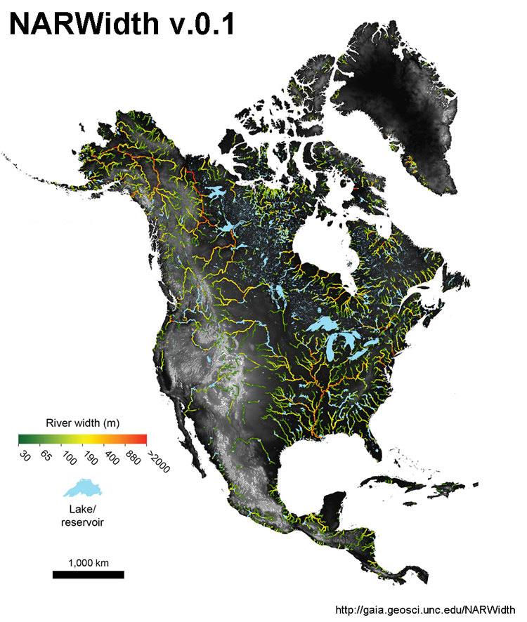
NARWidth v.0.1 contains 6.7 million georeferenced measurements of river width at mean discharge >=30 m and an additional 1.3 million flagged width measurements of reservoirs and lakes that are connected to the fluvial network. The data set includes measurements of rivers above 60°N, where high-quality river centerline and width data are largely unavailable, but excludes very large lakes (e.g., the Great Lakes), ephemeral streams, deltaic systems, and human-made canals. Additionally, NARWidth includes a braiding index field, defined as the number of channels at each river cross section. The braiding index only includes river channels wider than 30 m, a limitation imposed by the spatial resolution of Landsat imagery.
Data Format
NARWidth v.0.1 is available in a vector ESRI Shapefile and Comma Seperated Values (CSV) formats (see download page). The data set should be projected with the WGS84 datum.
At each measurement location, the NARWidth data set contains the following attributes:
1) width - river width at mean discharge (integer, units: meters)
2) nchannels - number of channels/braids (integer)
3) reservoir - resevoir flag where 0=river and 1=reservoir/lake (boolean)
4) lat - Latitude of river centerline (decimal degrees, floating point, datum: WGS84)
5) lon - Longitude of river centerline (decimal degrees, floating point, datum: WGS84)
Citation
We ask any users to cite this data in any published material produced using this data, and if possible link web pages to the NARWidth website (gaia.geosci.unc.edu/NARWidth/). If NARWidth becomes a substantial part of your work, please consider adding the data set developers as coauthors. The creators of this data set retain full ownership rights over it. The data set may be freely used for non-commerical scientific and educational purposes, provided it is described as the NARWidth Data Set and attributed to:
Allen, G. H., Pavelsky T.M., (2015), Patterns of river width and surface area newly revealed by the satellite-derived North American River Width data set. Geophysical Research Letters. doi: 10.1002/2014GL062764
Disclaimers
Distribution: Users are prohibited from any commercial, non-free resale, or redistribution without explicit written permission from the developers of NARWidth. Users should acknowledge NARWidth and its developers as the source used in the creation of any reports, publications, new data sets, derived products, or services resulting from the use of this data set.
No Warranty or Liability: Neither the authors of this data set, nor UNC, bear any responsibility for the consequences of using it, which are entirely the responsibility of the user. It is inevitable that a data-set of this size will contain errors and inconsistencies. However, these have been kept to a minimum and when they are identified they are corrected when resources permit. Updates to this data set are announced through the NARWidth web site.